Orchard Prairie Nature Mapping
Research Report - Spring 1997
Orchard Prairie Nature MappingResearch Report - Spring 1997 |
|||
|
|
|||
|
|
|||
| |
|||
Table of ContentsSpring 97 Research Findings Nature Maps Current Curriculum Possible Future Curriculum Additions Current Nature Mapping Resources Additional Nature Mapping Resources Appendix (Available On Request) Sample Charts Site Species Records, Totals and Average Summary of Species Journal Records Expedition, Location and Site Information Location Summary Site Summary Habitat Summary Species Summary Research Expedition Reports Species Report For Each Research Expedition Species Report For Each Site Species Report For Each Habitat Species Report In Alphabetic Order Species Report Of All Records Displayed Species Report Of All Records Before Display Conversion |
||
|
|
||
Orchard Prairie Nature MappingOrchard Prairie elementary school's nature mapping conducts nature research expeditions at four primary nature locations with the kindergarten through 7th grade students. Other nature places are also researched but not on a regular basis. These expeditions includes identification of species and habitat types at each location in a species journal.Nature mapping research in addition to classroom study, includes hands on interactive learning in nature settings. The term 'Nature Mapping' is used since the intent of the expeditions and classroom work is to map the local areas of nature that are studied. Species journal records from the study areas can be used to place species information on computer maps that then can be displayed and printed by the students. These nature maps can provide rapid positive feedback that allows students to learn about where they live and some of nature's inter-relationships. Sixteen of Orchard Prairie's 63 students participate in the full nature mapping curriculum. They range from the 2nd grade to 7th grade. These nature mappers are grouped into research teams of four students. There are also all school nature mapping research expeditions and classroom studies. Nature mapping research expeditions explore several nature locations each month. The primary nature research locations are the Orchard Prairie Wildlife Refuge, Sullivan Pond, Indian Painted Rocks and the Dexter nature place. All these sites are within the Little Spokane watershed where the students live. A nature place in Deer Valley near Newport was also explored this year. The Orchard Prairie Wildlife Refuge's seven (?) acres is within walking distance of the school. In addition to nature mapping research expeditions, native plant restoration projects are conducted here. The Wildlife Refuge provides an invaluable nature research area that can contribute significantly to student learning over the coming years. Sullivan Pond is within half mile of the school and includes a pond and wetland habitat. Indian Painted Rocks in the Little Spokane Natural Area includes riparian, forest and rockland habitat. The Dexter nature place is at a higher elevation with forest, pond and open field habitat. The Deer Valley nature place is at a higher elevation with forest and pond habitat. At each research location studied by the fourteen nature mappers, four research sites are identified. Each research team rotates through each site recording the species they observe in a species journal. After each research expedition the species journal records are consolidated into journal records for the expedition. These journal records along with information about the day and location are then to be entered into the Orchard Prairie's nature mapping data base and sent to Washington State's Nature Mapping Program, which is the outreach program for Washington's Gap Analysis Project at the University of Washington. These species records are then entered into Washington State's Natue Mapping Program database. Spring 97 Nature Mapping Research FindingsOrchard Prairie students went on 13 nature mapping research expeditions this spring. At the 5 nature mapping locations 18 research sites were studied. Sixteen generalized habitats (UW WA State GAP Analysis Habitats) were identified at these sites. The students consolidated species journal has 225 species records. A total of 665 individuals were counted on the research expeditions. There were 83 unique species identified. (See Appendix for detail reports)Most if not all of the research locations have not been researched by anyone in as much detail as what the Orchard Prairie students are doing. In the future accurate data from Orchard Prairie and other nature mapping schools can be invaluable for assessing changes in and around these areas and for the improvement of the quality of life in these areas. |
||
|
|
|||||
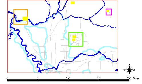
Nature MapsThe Nature Mapping computer is used to display the nature mapping expedition locations in color. The four primary nature mapping locations are displayed on a map of the north Spokane area, bounded by the Spokane River to the south and west with the Mt. Spokane foothills to the east and north almost to Greenbluff. The Spokane River and the Little Spokane River are displayed on the map along with a few of the major roads. |
|||||
Orchard Prairie Research Locations |
|||||
 |
|||||
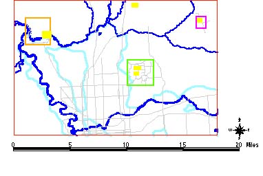
| Each location can be zoomed in to so the research sites and the topography of the location can be viewed. These detail location maps include each research site area, ponds, water flow areas and other information about the location. | |||||
|
|
||||
| Each nature mapping
expedition's species journal summary records are entered in to the computer.
These records are used for interactive displays of the locations and the
species. For instance, one of the 83 species names can be entered and the
computer will highlight the locations where the species has be identified.
The species identified for a particular site can be displayed.
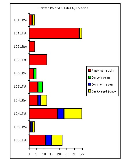
Charts and graphs can be made for selected locations, sites or selected species. For each species the number of times the species has been recorded and the total number of species recorded is displayed. |
||||
Sample Chart Showing Selected Species Counts At Each Research Location |
||||
 |
||||
|
|
|||
What is unique about
nature mapping learning is the research is done at local nature places.
Here the students are in their local environment and can relate what they
learn to other nature places near where they live.
Current Curriculum· Native plant planting at the Orchard Prairie Wildlife Refuge. As more native plants are planted and the plants mature significant changes in the species found in the Wildlife Refuge may be found in the nature mapping journal records. In the long run, local nature places like the Orchard Prairie Wildlife Refuge can provide insights into the quality of life in the area.· Bird species identification including how to use a bird field guide and binoculars. There are a wide variety of birds that can be identified at the research locations. The Little Spokane watershed has an abundance of bird species in the Spokane region. · Habitat identification · General plant, animal and fungi identification · General species and habitat inter-relationships · Nature mapping presentation to Spokane Audubon Possible Future Curriculum Additions· Water species, macroinvertebrates, identification· Insect identification. Insects, while sometimes over looked, can provide a significant opportunity for recording species. · Native plant identification · Habitat identification · The water cycle of each research location can be introduced · Watershed study · Topographic map information can be introduced for the research locations · Geologic and soil type information can be introduced for the research locations · Archaeology can be introduced for the research locations · By going to new nature mapping locations students can acquire skills in distinguishing between habitats and their species · Orchard Prairie nature mapping internet web site · Nature mapping using UW GAP Analysis Landsat information · Video Conferencing · Wildlife Refuge native plant and native grass planting in the fall and spring · Wildlife Refuge site design selection and implementation. At least 5 alternative site designs are sketched for the students to select from. The participating students develop criteria to use to make their decision on which alternative to implement. · Sending nature mapping research records to UW GAP program · Digital camera photo album · Video camera tape collection · A Nature Mapping Album recording each expedition and related classroom work, including digital photos, the journal summary and team journals. |
|||
|
|
||
Current Nature Mapping ResourcesField Research Resources· Bird Field Guides · Binoculars · Research clipboards and other materials · Transportation to nature mapping locations · Naturalist guidance at research locations · Digital Camera Mapping Resources · PC computer and monitor · Mapping software - Arc View · Arc View map customizing for research locations Additional Nature Mapping ResourcesThe following are areas where additional resources can significantly benefit these possible curriculum additions.Field Research Resources · Waterspecies, macroinvertebrate field guides · Insect field guides · Native plant field guides · Habitat field guides · Watershed guides · Local, regional and global nature maps · Transportation to nature research locations · Naturalists guidance at research locations (macroinvertebrates, insects, habitats ...) · Binoculars for bird study · Magnifying glasses for insect study (20 ?) · Microscope for water study · Low end tape recorder · High end tape recorder for recording bird and other nature sounds · Video camera to record nature mapping expeditions, species and habitats · Topographic maps of research locations Mapping Resources · Color printer to print the nature maps · Internet, world wide web and email, facility working, including a working modem connection · Additional Arc View nature map data sets · UW GAP Analysis data sets for the Orchard Prairie Research Locations · Additional Arc View nature map customizing · Create an Orchard Prairie Internet web site where Orchard Prairie research is displayed and updated · Set up and coordinate sending nature mapping records to UW GAP program |
||
|
|
|||
| Wildlife
Refuge Restoration
· Native plants and grasses to be planted in the fall and the spring · Drawing of possible refuge site designs - at least 3 alternative designs · Land form adjustments to the refuge - pond ... Other Resources · Video Conferencing set up and coordination |
|||
Orchard Prairie Nature Mapping Expedition JournalDate: _____________________ Precipitation: ______ Expedition # ___________ Sky: ___________________________________ Research Team: _____________________________________________________________________ Township/Range: _______________________ Latitude/Longitude _____________________ Site Codes: a) ________________________ b) __________________________ c) ________________________ d) __________________________ |
||
| Species
Name Species Code Saw Heard Smell
Tracks How Many Site Code
Comments
1 2 3 4 5 6 7 8 9 10 |
||
|
|
|||
AppendixSample Charts Site Species Records, Totals and Average Summary of Species Journal Records Expedition, Location and Site Information Location Summary Site Summary Habitat Summary Species Summary Research Expedition Reports Species Report For Each Research Expedition Species Report For Each Site Species Report For Each Habitat Species Report In Alphabetic Order Species Report Of All Records Displayed Species Report Of All Records Before Display Conversion |
|||
Copyright 1997 Little Spokane Watershed Council Revised 10/28/97